
GLOBAL WEATHER DESK
A massive, deeply buried reservoir of ocean heat traveling across the equatorial Pacific has triggered an atmospheric “Code Red,” with international meteorological agencies warning that a powerful, potentially record-breaking Super El Niño is rapidly consolidating for late 2026.
Data from major global forecasting bodies—including the United States’ NOAA, Europe’s ECMWF, and Australia’s Bureau of Meteorology (BOM)—have aligned on an alarming, high-impact trajectory. Current climate models indicate a 96% probability that this warming cycle will stubbornly persist through the Northern Hemisphere winter of 2026–2027, with many projections showing ocean temperature anomalies soaring past the extreme +3.0o C to +4.0oC thresholds. If verified, this event could rival or completely surpass the most catastrophic “Super El Niños” in recorded history, such as those in 1997–1998, 2015–2016, and even the legendary event of 1877–1878.
The Current Situation: What Satellite Eyes See Now
The official reference climate satellite, Sentinel-6 Michael Freilich (a joint NASA-European Space Agency mission), has captured the unambiguous blueprint of this impending crisis in real time.
By charting sea-surface height down to fractions of an inch, the satellite detected brief bursts of westerly winds in the far western Pacific near Micronesia earlier this year. These wind bursts destabilized the ocean, triggering a series of massive underwater swells known as Kelvin waves.
Because water expands physically as it absorbs thermal energy, tracking sea level elevation allows scientists to measure exact subsurface ocean temperatures. The satellite data reveals that a fresh, highly energetic Kelvin wave that emerged in March has now fully marched across the ocean. As a result, surface waters off the coasts of Peru, Ecuador, and Colombia are already more than 5.9 inches (15 centimeters) higher than long-term historical averages—a clear indicator that a monumental reservoir of heat is breaching the surface.
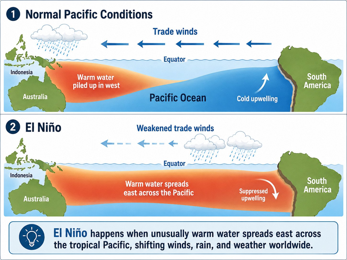
How It Works: The Engine of a Super El Niño
To understand a “Super” event, one must understand the standard El Niño-Southern Oscillation (ENSO) climate cycle:
- Normal Conditions: Strong easterly trade winds blow from east to west across the equator. This acts as a broom, pushing warm surface waters toward Indonesia and Australia, while allowing deep, freezing, nutrient-rich water to rise (upwelling) along the coast of South America.
- The El Niño Shift: For reasons scientists are still mapping, the trade winds weaken or completely reverse into “westerly wind bursts”. The massive pile of warm water trapped in the western Pacific loses its counter-force and sloshes violently backward toward South America via Kelvin waves.
- The “Super” Escalation: In a standard event, the warming is modest and contained. However, a Super El Niño acts as a massive planetary “pressure release valve”. The current 2026 Kelvin wave is carrying an unprecedented baseline of background heat because the global oceans and atmosphere are already at record-high baseline temperatures due to broader climate changes. When this massive underwater thermal pulse completely shuts down the cold South American upwelling, it throws a chaotic wrench into the global jet stream.
The Global Update: Expected Planetary Shockwaves
Because El Niño peaks in intensity between November and January, the domino effects on world trade, agriculture, and human safety are projected to unravel rapidly over the coming months:
| Region / Sector | Expected Impact of the 2026 Event |
| Global Temperatures | Releases massive ocean heat into the atmosphere, threatening to make 2026/2027 the hottest years ever recorded on Earth. |
| South & Southeast Asia | Drives severe droughts, historic heat waves, and a severely weakened Indian Monsoon, threatening food security and water reserves. |
| The Americas | Triggers intense flooding, mudslides, and coastal hazards in Peru/Ecuador, while shifting storm tracks to cause torrential winter rain in California. |
| Australia & Africa | Promotes crippling aridity and extreme drought conditions, dramatically elevating the risk of catastrophic wildfires. |
| Global Food & Marine Economy | Marine heatwaves will trigger severe coral bleaching, while the lack of nutrients off South America will devastate local commercial fisheries. |
“Every El Niño is different,” warned Dr. Severine Fournier, deputy project scientist for the Sentinel-6 mission. “But they almost always make for a hot year and big changes in rainfall in parts of the globe.” Governments worldwide are urged to leverage these satellite early warnings to shore up coastal defenses, manage agricultural water allocations, and brace for extreme weather anomalies.